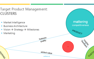
7 08, 2013

Czech LPIS by Sitewell

2018-05-06T14:32:41+02:00August 7th, 2013|Featured, Projects|0 Comments

The Czech LPIS project represents a new philosophy in the solution of a geographic information system for agricultural parcel identification. Its basic objective is to provide high quality data about the agricultural land use, allowing for a trouble-free administration and control of agricultural aid applications. Czech LPIS is based on a seamless central database on the Oracle Spatial platform, updated on-line in real time over a virtual secure network. 4D …

17 04, 2013

Sitewell Golam

2018-08-31T14:30:15+02:00April 17th, 2013|Projects|0 Comments

Sitewell Golam represents new process oriented approach to all-in-one assets management with geospatial features and analysis for land assets (parcels/buildings/space units). All processes are securely managed based on organizational structure, roles and rules. All phases of management from purchasing, servicing, sales or all operational tasks etc. are covered seamlessly in one open SaaS portal. Important functionality is dedicated to detailed spatial pasportization of buildings including drilldown of costs and revenues …

24 07, 2009

Geospatial Intelligence Is Replacing Traditional GIS

2018-08-31T14:29:50+02:00July 24th, 2009|Perspectives|0 Comments

The volume of data on internet, including maps is rapidly growing up. But gives information every time sense? Aren’t we sometimes overloaded with low quality unstructured data? Could something help on internet with better quality of data? Now we are facing period of scrabbling and grabbing and concentrating huge data. Internet is full of anonymous data, many times published by enterprises. Do we face strong managed manipulation or is it …

Go to Top